In recent years, finding great photography locations has become easier than ever. The internet puts many corners of the world at our fingertips and allows us to learn about them, and potentially even view them, before even stepping outside our own doors. Depending on what type of photography location you are looking for, different research strategies may be more helpful than others. However, if you know where to look, you can do an extensive amount of preliminary photography scouting on your phone or computer from the comfort of your own home or while you are out on the road and trying to decide where to go next.
Google Earth/Maps (Desktop and Smartphones)
 Google Earth and Google Maps are incredibly powerful tools for those who want to be able to have the world at their fingertips and explore possible photography locations in any given area. Google Earth, which is downloadable to a laptop or desktop computer, as well as tablets and smartphones, allows you to search a given area from a bird’s eye view, while also integrating other features to help supplement your search.
I personally use Google Earth and Google Maps when I am trying to explore a photography location that will be difficult to access in real life. For example, when planning out locations to view the 2017 total solar eclipse, I used Google Maps to view which areas were along the path of totality, eventually choosing a location based on its accessibility and that it was on public land, thereby giving me the most freedom to move around the area freely. I used the Terrain layer in Google Maps to search for a vantage point that would be in the path of totality and at one of the higher elevations in the national forest which I had chosen to visit. After finding some topographic features that looked interesting, I switched to the Aerial layer to see satellite images of those spots, which helped me see which of them would be obscured by trees and which would have a clear view.
After choosing a few possible locations, I typed in directions from Seattle to see which of them would involve a very long drive, and which would involve a drive that was a total deal breaker. I saved the locations that seemed like they would be reasonably accessible and jotted a few notes so that I could access them in Google Maps later on. For a location that was across the country from me and had very few photos of it available, Google Earth and Google Maps were invaluable during the process of finding a photo location for the total solar eclipse, especially since some of the options below may or may not be able to help with spots that have not been photographed often in the past.
Really Good Photo Spots App (iPhone, iPad)
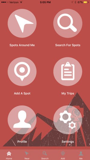 Really Good Photo Spots (rGPS), is a photography locations app from the brain of Jim Harmer which grew from the idea that photographers are becoming more numerous and the popular locations that are seeing higher and higher volumes of visitors are getting damaged as a result. Really Good Photos Spots allows users to input photography locations into the app, accompanied by pictures and other information, allowing other users to search for and find known locations in a given area. The app is ideal for those who not only want to see the popular locations, but also want to be able to find spots nearby to them that are rated for their quality. For example, if I am driving through New Hampshire, sunset is in two hours and I don’t know where to go to shoot it, rGPS can tell me what locations are within a certain number of miles from me and help me decide where I want to go.
Jim spent what I assume was many sleepless nights making this app useful for the masses, but I technically can’t confirm that since I don’t watch Jim sleep. Regardless, rGPS is an app to have on your smartphone or tablet to not only find some of the lesser known spots to photograph, but also to get yourself to a location nearby when the light is getting good and you need somewhere to shoot.
PlanIt! For Photographers (iOS and Android)
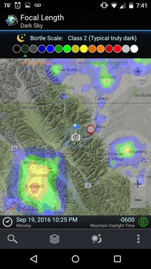
PlanIt! For Photographers (PIFP) is a clumsily named but enormously useful app that has been irreplaceable during my photography planning in recent years. PIFP integrates with Google Maps and various other features to give you an all-in-one photography planning tool. The app can provide terrain maps to help give you an idea of the topography of a certain area, aerial images to show what the area looks like from a bird’s eye view, ephemeris features to show where the Sun, Moon, and Milky Way will rise and set at any location at any time, how light pollution affects your shooting location, and even what the landscape and topography will look like in your frame at any focal length.
PIFP is an ideal app for those who want to see how big a mountain will look in their composition or where the Sun, Moon, or Milky Way will be positioned at a given hour. I have used the app consistently over the years to catch the Moon rising in a perfect location, to see how the Milky Way will line up with a mountain in my midground, and countless other photography planning scenarios. PIFP is an app I can’t recommend enough.
PhotoPills (iOS and Android)
If all the descriptions I wrote above regarding PIFP sounded suspiciously like PhotoPills, it is because they are very similar apps. Up until recently, PhotoPills was unavailable for Android users, which was a gap that was filled nicely by PIFP. Like PIFP, PhotoPills allows you to see how your composition will look at any given time in any given location, integrating maps, ephemeris features, and much more. From everyone I have spoken with, both PIFP and PhotoPills have a bit of a learning curve that needs to be navigated before you can unleash the full power of either app; however, spending the time to do so is more than worth it. At the time of this writing, the only major differences I can notice include that PIFP includes tidal information and integrates a Bortle Dark Sky map into its map layers, the latter of which PhotoPills is supposed to be adding soon.
500px
500px is one of the internet’s best places to go when you want to realize there are a countless number of other photographers creating images that blow yours out of the water—or, at least that is my experience when visiting the site. However, aside from bringing your ego down a peg or two, 500px is a great tool to help you find beautiful photo locations or figure out what types of shots are possible at the locations you are already aware of. I personally tend to use 500px’s map function to try to find locations near an area I plan to be visiting or search for that location to get an overall feel for an area. If I am planning to visit a popular photo location, I tend to try to search for the obvious compositions from those spots so I can get an idea of what everyone else’s photos look like so I can try to get a fresh composition when I visit.
While it sometimes involves sifting through piles of selfies and photos of someone’s cat, Instagram can be an invaluable photo planning tool, even if it isn’t always the most efficient. I tend to use Instagram not only to find photo locations, but to get an idea of what current conditions look like at those spots. Unlike sites like 500px, many users tend to post to Instagram within a day or two of taking a photo, especially if it is a cell phone shot. Getting views from a mountaintop is certainly valuable, but finding recent photos posted from that mountaintop that show me if there is still ice or snow cover can help me properly plan for the current weather conditions, or plan to try a different location instead. Outside of landscape photography, the way that Instagram is used by many people also allows finding if there may be events in a certain area, construction that might be obstructing a view we want to capture, or any other number of factors that can be discovered by scrolling through recent photos from a given location.
Travel Websites
While not photography specific, travel websites can be valuable tools for figuring out spots you may want to photograph in an area you will be traveling to. There are large sites like TripAdvisor that list the most popular places to visit in many locations. However, do not overlook local tourism pages or travel blogs as other ways to find spots to photograph while you visit a certain area. Keep in mind that if you find a location prominently featured on some of the larger travel websites or official tourism pages, chances are it is a spot that will be fairly busy, depending upon when you actually makes your visit. However, some of the smaller independent travel blogs, or even just blogs you stumble upon from avid hikers documenting their climbs or food enthusiasts reviewing a restaurant, can be great resources for finding some lesser known spots that are ripe for photography.
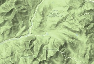
CalTopo (Desktop)
While this section is really just meant to tout the benefits of topographic maps in general when planning out photo locations (mainly ones involving the landscape), CalTopo is the one that I have used online many times to help find my photography locations. The site excels where the Terrain layer in Google Maps lags a bit. CalTopo provides satellite maps like Google Earth does, but builds upon this strength by adding several different types of detailed topographic maps. During my trip for the 2017 total eclipse, I knew I would eventually be without cell phone reception, so I used CalTopo to print out large topographic maps of the areas I wanted to explore. For those who are not a big fan of carrying good old fashioned paper maps, I have also downloaded PDFs off of CalTopo onto my phone or taken screenshots so that I can take my planning materials into the field with me. CalTopo is not only useful in finding photo locations, but the elevation contours, roadways, and trails shown on the maps also make the maps useful for navigating to the locations you choose.
Website of Local Photographers
I like to get off the beaten path and explore a bit when I take photos. However, in many places that I visit I only have a limited amount of time, so I at least want to feel like there’s a chance I have a few photo opportunities that I am reasonably happy with when I make a decision of where to explore. Since I know there have to be other photographers out there with the same mindset as me, I often look at websites and portfolios for photographers based in the areas I am visiting to see what they shoot. This doesn’t mean go look at their websites and copy all of their compositions, but it does mean that while you might be visiting a high-traffic location such as a national park or a major city, a local photographer has probably explored enough that they also have shots in nearby state parks or towns that area also worth seeing. Brushing up on the portfolios of local photographers might help you come away with some lesser known spots to explore.
Final Thoughts
There is no wrong way to find spots where you want to photograph. While the tools above are all helpful ways to focus on where you would like to scout more in person, it is beneficial to always keep your eyes and ears open during your day to day activities. You never know when an idea for a possible location will pop into your head. There is a never-ending bounty of resources accessible through old computers, tablets, and smartphones. Which ones are your favorites?
Good selection, but misses Photographer’s Ephemeris (iOS/Android app, website), which is the most functional of all, IMO.
How many miles does this vehicle have on it?
Just thought I would leave an oldie but a goodie for me. Flickr has an option to Explore the map for photos which for me has been handy to scout out interesting photo locations that I never knew existed. It is one of my primary tools, along with The Photographers Ephemeris, another handy app for sunrise/sunset planning
I use http://aroundme.photos that shows pictures taken in certain area. Highly recommend
SnappGuides are great.
Have a great day Kevin and readers 🙂
Yes, the article I was looking for. Your article gives me another approach on the subject. I hope to read more articles from you.
Good article and knowledge for me! I found a lot of information here! This article is really good for all newbie here. Thank you for sharing with us! Good luck!