In the world of landscape photography planning applications, PhotoPills is the app I hear raved about the most often. In various articles, podcasts, and conversations with other photographers, I’ve repeatedly heard about how the app has revolutionized the process for planning out landscape photos in particular. Since PhotoPills is currently only available for Apple devices, however, I at one time found myself considering a switch from Android to an iPhone simply so that I could have all that PhotoPills has to offer at my fingertips. Luckily, I found PlanIt! for Photographers (PIFP from here on out), and have squashed the thoughts of buying a whole new type of phone simply to buy a photography app. (Note: This article is not at all about iPhone versus Android. So, you know, just don't…)
Let me start off by saying that I’m not affiliated with PIFP, nor did they request this post. I simply wanted to give everyone a rundown of what the app has to offer since it has been so beneficial for my photography planning. For those that don’t yet have access to PhotoPills (which is rumored to be coming to Android as early as the end of 2016) or for iOS users who may want to consider a different option, PIFP could fill that need.
Introduction
In a nutshell, PIFP is set up to be a do-it-all photography planning application that you can carry around in your pocket. Personally, I use it for planning many of my landscape shots, especially those that involve the Milky Way or are heavily dependent on the location of the Sun or Moon. And, aside from having a pretty awful name (I would be in full support of a name change), the app has been a huge asset to my photography. Like The Photographer’s Ephemeris (TPE), PIFP offers the ability to see locations of the Sun and Moon at various times of the day and in various locations. However, the app dives much further into the planning aspect of photography, offering several additional features that, in my opinion, make it much more useful.
Keep in mind that with an app that does so much, there is certainly a learning curve involved. I remember being a bit lost when I first got the app, finding the menu system to be a bit confusing and sometimes repetitive. Like with any new tool, however, once you get the hang of it, it can become indispensable. For reference, PIFP offers a free version with limited features, as well as a “Pro” level app which costs $5.99 at the time of this writing. I’ll be going over the pro version in this post, because it quite honestly may be the best $5.99 I’ve ever spent on my photography. For the examples in this post, I'll use a location and composition I recently visited in Glacier National Park: the view of Hidden Lake and Bearhat Mountain from the Hidden Lake Overlook.
Settings
The first step towards successfully using PIFP is inputting a few settings to make sure the information it gives is useful to you. The absolute minimum is making sure you have the type of camera you’re using set in the app so that things like focal length and depth of field are as accurate as possible. Many of the other settings are up to preferences, so take a look through the menu to figure out how you will like your information displayed.
Basic Navigation
To try to quickly wrap your head around the organization of PIFP, it is best to take note of the three main menus that are offered in the app: Backgrounds, Tools, and Ephemeris Features. Backgrounds determines whether you will be planning using an aerial map view or a representation of your camera’s viewfinder in a given location, Tools lets you plan things like focal length and depth of field at specific locations of your choosing, and Ephemeris Features offers information on location and timing of both space and earth-bound objects.
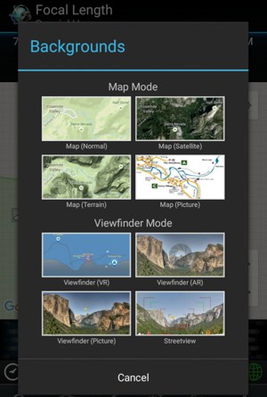
Backgrounds
Choosing a background is typically my first step in the planning process. PIFP breaks backgrounds down into two categories: Map Mode—which appears to use the same maps used by Google, meaning you have a simple map, topographic map, and satellite aerial map at your fingertips—and Viewfinder Mode, which displays a representation of your cameras viewfinder with the location and focal length of your choosing.
In Map Mode, I typically switch between the topographic map and the satellite map depending on what type of shot I am trying to plan. PIFP also offers the ability to load your own map image to work from, which I have never used. In Viewfinder Mode, PIFP offers Viewfinder (VR), Viewfinder (AR), Viewfinder (Picture), and Streetview. I almost exclusively use the Viewfinder (VR) mode, which, after I choose my location, the direction I want to point my camera, and my focal length, shows what my camera’s field of view will be, including features such as mountains, the Sun, and the Moon. While the Viewfinder (AR) function is an interesting idea (taking a photo in real time to see when the Sun, Moon, Milky Way, etc. will line up with that view), I’ve never found it to be accurate enough to rely upon, and, as a result, never use it.
If you are working with a Background, once you choose your map you can place where your camera will be and also the object it will be pointing at (a mountaintop, a certain building, hopefully not into anyone’s windows, etc.). Once you have your location and your subject chosen, you can use that information to switch into a Viewfinder Mode to find out some of what your camera will be seeing at a given time.
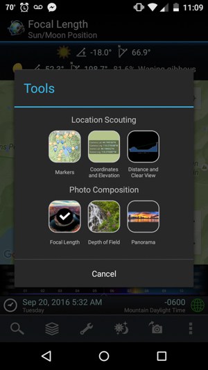
Tools
PIFP breaks the Tools menu down into two different planning focuses: Location Scouting and Photo Composition. The Location Scouting section allows you to set markers for locations you want to save, find coordinates and elevations of a given location, or, my personal favorite, find distance and “clear view” in a given area, meaning you can see what mountains or hills may be blocking your view of the horizon, and how it might affect your view of the Sun, Moon, or Milky Way from where you will be standing.
The Photo Composition section features three other tools: Focal Length, Depth of Field, and Panorama. I find the Focal Length tool to be by far the most useful, allowing me to show an overlay of what my camera’s field of view will be at a given focal length (in portrait or landscape mode), which can tell me which lens I may need or not need for a specific shot, and potentially allow me to save space and weight in my camera bag on a long hike. I personally do not use the Depth of Field or Panorama Tools, since these are more on-the-fly things I tend to evaluate when I’m in the field and don’t require too much planning.
Ephemeris Features
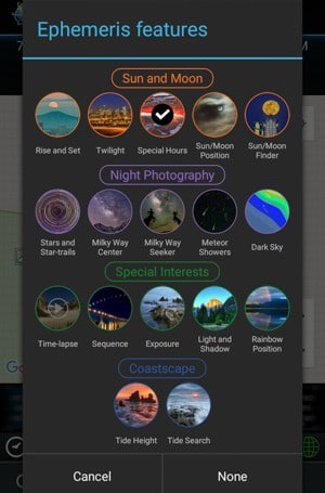
Ephemeris Features is the third portion of PIFP’s menu system, and this is where the level of detail that the app provides really shines. The Ephemeris Features menu includes 17 different features, which are broken down into subcategories of “Sun and Moon” (Rise and Set, Twilight, Special Hours, Sun/Moon Positions, Sun/Moon Finder), “Night Photography” (Stars and Star-trails, Milky Way Center, Milky Way Seeker, Meteor Showers, and Dark Sky), “Special Interests” (Time-lapse, Sequence, Exposure, Light and Shadow, and Rainbow Position), and “Coastscape” (Tide Height and Tide Search). We’ll dig into what each of these features below to show how PIFP can help you improve your photo planning.
Sun and Moon Ephemeris Features
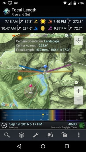
Rise and Set
The Rise and Set function in PIFP functions in the essentially same way that TPE does. Once you select the date you want to take your shot, lines appear showing the rise and set points of both the Sun and the Moon. This feature is one of the shining features of PIFP, allowing you to see when a rising Full Moon or setting Sun will line up with a composition you are envisioning. It is not, however, a unique feature.
Twilight
The Twilight feature functions similarly to the Rise and Set function, showing line overlays of the Sun at sunrise and sunset, but also during at Civil, Nautical, and Astronomical Twilight, the latter of which indicates the time when the sky is fully dark for astronomical purposes. Honestly, the line overlays on the map with this feature are pretty unnecessary, but the times help for planning when things like blue hour or a truly dark sky will occur.
Special Hours
The Special Hours feature speaks in a language more common to photographers, using the same function as the Twilight feature to show when Golden Hour, Blue Hour, and Night begin and end over the course of the day.
Sun/Moon Position
A somewhat repetitive feature, displaying nearly the same information as the other Sun and Moon features.
Sun/Moon Finder
The Sun/Moon Finder is useful for if you want to know a date and time when the Sun or Moon would line up with a chosen composition. This feature gives a list of possible days when a specific shot will be possible, giving you a list of possible shooting times for the image you have in mind.
Night Photography
Stars and Star-trails
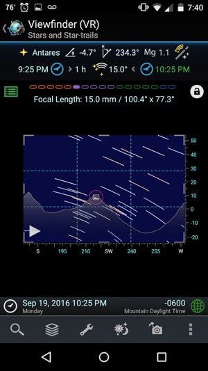
The Stars and Star-trails feature serves a few different purposes, the main one being that it allows you to preview what star trails will look like in your composition based on how long of an exposure you choose. If you are hoping for a certain length of star trail in your image, this can help to take the guesswork out of how long your total exposure time should be. The feature also has a tool that allows you to calculate what length of exposure you will need to avoid star trailing in your shot, which can be calculated by the 600 Rule, 500 Rule, the circle-of-confusion associated with your focal length.

Milky Way Center
For me, the Milky Way Center feature is one of the bread and butter tools of PIFP. This feature overlays the position of the Milky Way (depicted by a line of red dots for the spiral arms and green dots for the center of the Milky Way) onto your map so that you can see if and when the Milky Way will be visible in your desired composition. In Viewfinder Mode, the Milky Way core shows up in your chosen field of view, which has been worth every penny and more of that $5.99 I spent. The only gripe I have with this feature is that it would be more helpful in Viewfinder mode to have the Milky Way show up as it actually looks instead of a line of green and red blobs.
Milky Way Seeker

The Milky Way Seeker works in a similar way to the Sun/Moon Finder, allowing you to determine when the Milky Way will be visible in a chosen composition. I don’t use this feature often, most likely because it gives me a written list of possibilities instead of a graphical representation. I’m a visual person, so I much prefer to just scroll through dates to see when and where the Milky Way will line up with my shot. To others, however, this could be a very useful feature.
Meteor Showers
The Meteor Showers feature in PFIP is more of a quick reference than it is a consistently useful tool. The feature lets you select a specific meteor shower throughout the year, and the app will display the dates the shower will be active, the peak date, and, in viewfinder mode, which part of the sky the meteors will appear to originate from. I haven’t used this feature much, but I also haven’t gotten a chance to shoot a meteor shower recently. In doing the research for this article, however, I did notice that the Geminids—one of the largest meteor showers of the year that typically peaks around December 14th—are not listed as a possible option for meteor showers.
Dark Sky
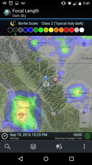
The Dark Sky feature is one of my other favorite tools in PIFP, allowing me to easily check if a desired shooting location is dark enough to see the Milky Way. The feature overlays a color-coded scale representing the Bortle Dark Sky Scale onto the map, showing warmer colors for light-polluted areas and cooler colors for darker skies. For those who aren’t well-versed in Bortle, the app provides excellent descriptions with both pictures and complicate numbers to show what each number on the Bortle scale means. While this tool is available online, I have never previously found a version that works well on a mobile device, so PIFP integrating it into the app is huge. Also, as far as I know, this feature is not available in PhotoPills, giving PIFP a unique advantage for night sky photographers.
Special Interests
Time-lapse
The Time-lapse feature is essentially a calculator that allows you to plan out a time-lapse clip, letting you input parameters such as the desired clip length and shooting interval to determine what else you need to know to set up the time-lapse (ex. how many shots to take). One handy function of this tool is that when choosing your desired shooting interval, PIFP will mention which intervals are good for what scenario. For example PIFP recommends one second for moving traffic and 10 seconds for slow-moving clouds.
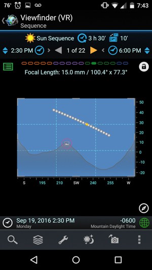
Sequence
Similar to the Time-lapse feature, the Sequence feature comes in handy for when you plan to shoot a composite of the Sun or Moon moving across the sky over time. For example, if you want to shoot a composite of the progression of a solar or lunar eclipse, the Sequence feature can help with your planning.
Exposure
The Exposure feature is another calculator that comes in handy when out shooting. This feature calculates a change in exposure in the event that you want to add an ND filter to the mix, for example. Take your initial proper exposure and PIFP will calculate the equivalent exposure with your specific type of ND filter attached. I’ve also used this function to determine what settings I will need for a foreground exposure at night after I take what I consider to be a properly exposed shot at a silly high ISO setting.
Light and Shadow
The Light and Shadow feature is set up to use information about the terrain surrounding your shooting location to determine what shadows will be cast on your scene. Honestly, I didn’t know this feature existed until I started writing this paragraph. At first glance, however, I think it could be extremely useful, if accurate, for planning out lighting in a hilly or mountainous shooting location.
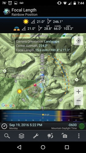
Rainbow Position
Rainbows are one of those fickle yet majestic sights that can push a good landscape photo to the next level. I’ve never actively tried to plan to have a rainbow in my photo before. However, after accidentally shooting two sunrise rainbows on a recent trip to Glacier National Park, I’m wondering if I should start considering it more often. As a way to check PIFP against the real thing, I can confirm that the rainbows that I saw in Glacier showed up where the app said they would be.
Coastscapes
Tide Height
The Tide Height feature allows you to see what the tide level will be in your shooting location at a given day and time. The feature lets you select a tidal location, tells you how far away it is from your shooting location, and shows you when high and low tides are that day, as well as how high they will be. For those planning a seascape shot by the ocean, this can come in very handy.
Tide Search
If the Tide Height function doesn’t tell you that tides are favorable on the day and time your chose, you can use the Tide Search feature to find out when the tide will be at a certain height at your shooting location. If, for example, you are planning a shot in a sea cave and shooting during high tide will wash you out to sea, searching for low tides at your shooting location with tide heights below a certain level could help you from becoming photographer flotsam.
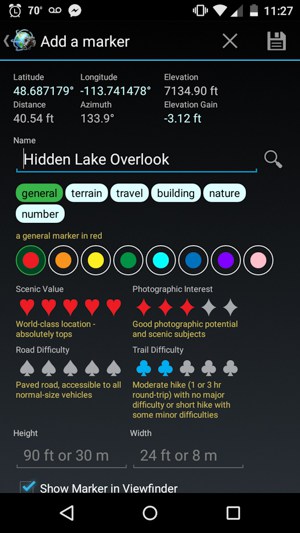
Markers
The Markers function is PIFP’s map-integrated, user-generated photo location catalogue that you can create and personalize for yourself. Think of it as Google My Maps, except specially designed for you to input information about your photo location with a few quick touches. I use this function to keep track of the different compositions I'm planning to visit throughout the year and various bits of information about them that would be useful to remember.
Offline Functionality
From what I can tell, calculators and reference simulations like the star trails feature work without an internet or data connection. However, when offline, elevations disappear and maps don’t seem to load, so plan ahead by taking screenshots if you plan to be outside of cellular service and will want to reference the app.
Final Thoughts
Without having used PhotoPills for myself, I can’t give a direct comparison between it and PIFP. In its own right, however, PIFP is an immensely useful tool for photography planning. While its feature organization can be repetitive and a bit confusing at times, these issues don’t take away from the ultimate usefulness of the app. For me personally, the Milky Way planning feature and Dark Sky feature have been worth the $5.99 on their own. Landscape photographers—especially those using Android devices—should definitely give PIFP a try.
Hi! This is Rafael (the bard) from the PhotoPills team, writing from Photokina photo fair! I just want to say congrats to Kevin for this great article and also to the other app developers like Planit, TPE, Sun Survayor or Sunseeker. You’re doing a great job! 😉
Here are the good news!
Androids! I’m so excited to announce thad we’re working so hard to have PhotoPills ready for android next Christmas (December 2016)… Android is our next big thing!
So, if you’re a PhotoPiller in your heart… we’re happy to welcome you to the tribe. You can join our Android notification list and we’ll let u know when is ready: http://www.photopills.com/faqs
We’re ready to help you turn your creative ideas into real photos.
Keep pushing imagination guys!
i wonder why I’ve never heard of this app, since it looks like it was made circa 2012. excited to try it out on a shoot!